


crêt de chalam et borne au lion

Pascal Gueno
User
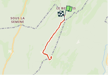

Length
6 km

Max alt
1524 m

Uphill gradient
234 m
Km-Effort
9.1 km

Min alt
1284 m

Downhill gradient
239 m
Boucle
No
Creation date :
2025-07-01 07:29:00.558
Updated on :
2025-07-01 17:13:17.236
1h41
Difficulty : Easy

FREE GPS app for hiking
 SityTrail
IGN / Geographical institutes
SityTrail Plus
The world is yours!
About
Trail Walking of 6 km to be discovered at Bourgogne-Franche-Comté, Jura, La Pesse. This trail is proposed by Pascal Gueno.
Description
départ du grand parking de la borne au lion à 4 kms de la pesse
Positioning
Country:
France
Region :
Bourgogne-Franche-Comté
Department/Province :
Jura
Municipality :
La Pesse
Location:
Unknown
Start:(Dec)
Start:(UTM)
721089 ; 5127698 (31T) N.
Comments
Très beau point de vu sur le mont blanc